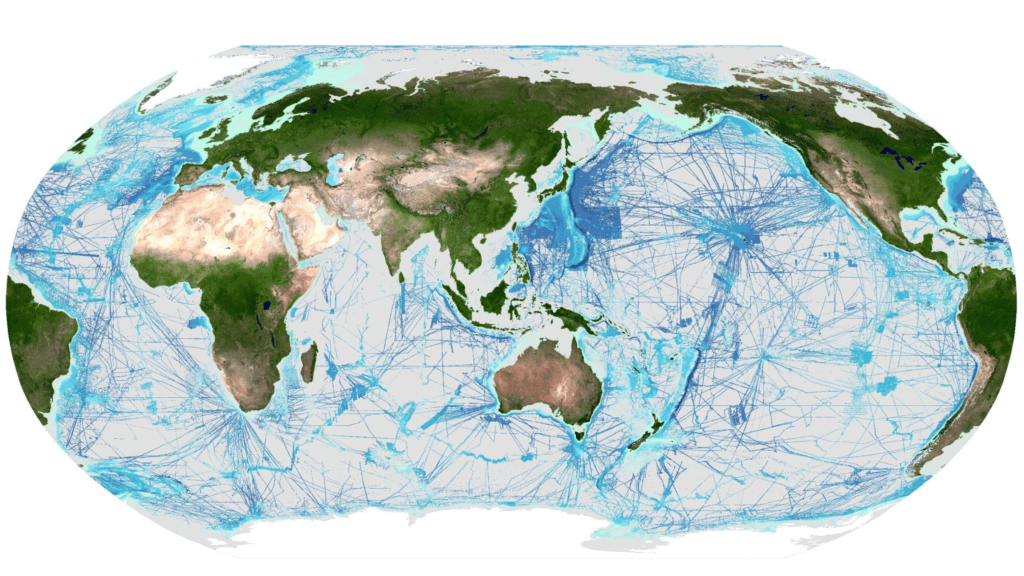
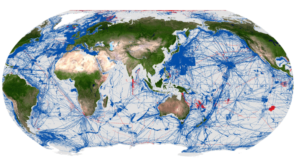
Credit: Seabed 2030
New data contributions add over four million square kilometers of seabed to the definitive map of the ocean floor in the last year
London, 21 June 2025 – On World Hydrography Day, The Nippon Foundation-GEBCO Seabed 2030 Project has announced that 27.3% of the world’s ocean floor has now been mapped to modern standards. The increase in data represents more than four million square kilometres of newly mapped seafloor – an area roughly equivalent to the entire Indian subcontinent.
This milestone comes at a pivotal moment. Just last week at the third UN Ocean Conference in Nice, the global ocean community united in a call for urgent, inclusive and transformative action – recognising the ocean’s central role in addressing some of the planet’s greatest challenges, from climate resilience to food security. Yet despite covering more than 70% of Earth’s surface, the ocean remains our least understood environment.
Established by the International Hydrographic Organization (IHO), World Hydrography Day raises awareness of the critical role hydrography plays in advancing our understanding of the ocean. This year’s theme, ‘Seabed Mapping: Enabling Ocean Action’, highlights how bathymetric data underpins the blue economy – supporting sustainable marine energy, coastal tourism and fisheries – and contributes to global efforts to protect biodiversity and tackle climate change.
Seabed 2030 is a collaborative project between The Nippon Foundation and the General Bathymetric Chart of the Oceans (GEBCO), which seeks to accelerate the complete mapping of the world’s ocean floor and compile all the data into the freely available GEBCO Ocean Map. As a flagship programme of the Ocean Decade, Seabed 2030 is helping to close one of the largest data gaps in ocean science.
From improving tsunami early-warning systems to guiding the installation of undersea cables and identifying biodiversity hotspots, seafloor data enables informed, real-world action.
Over the past 12 months, Seabed 2030 has welcomed data contributions from 14 new organisations – including first-time contributions from five new countries: Comoros, Cook Islands, Kenya, Mozambique and Tanzania. With data now contributed by over 185 organisations worldwide, the project continues to galvanise global support towards a fully mapped ocean floor.
Commenting on the latest milestone, Seabed 2030 Project Director Jamie McMichael-Phillips said: “Mapping the seafloor is not just a scientific exercise – it’s a global imperative, foundational to everything from climate action and coastal resilience to sustainable development.
As we reach the midpoint of the UN Ocean Decade – a defining moment for ocean action – I urge governments, industry, research institutions and individuals alike to contribute to this global effort. Together, we can deepen our scientific understanding of the ocean and help secure the future of the blue planet.”
Executive Director of The Nippon Foundation, Mitsuyuki Unno, said: “The Nippon Foundation is committed to building on the achievements made through Seabed 2030 by continuing to support global collaboration to acquire bathymetric data, the promotion of innovative ocean mapping technologies, and the training of future ocean mappers.”
Chair of GEBCO Evert Flier added: “The progress captured in this update reflects the extraordinary value of global collaboration. Every contribution strengthens the GEBCO Grid – helping to complete the picture of the ocean and deliver benefits for science, society and the planet.”
All data collected and shared with the Seabed 2030 project is included in the free and publicly available GEBCO global grid. A joint programme of the IHO and the Intergovernmental Oceanographic Commission (IOC) of UNESCO, GEBCO is the only organisation with a mandate to map the entire ocean floor.