


 30 January 2014 – UKHO Launches Large-Scale Routeing Chart for Vietnam, Indonesia and the Malacca Strait. Routeing Chart 5141- ‘Malacca Strait to Marshall Islands’ – adds to UKHO’s upgraded suite of navigational products for Vietnam
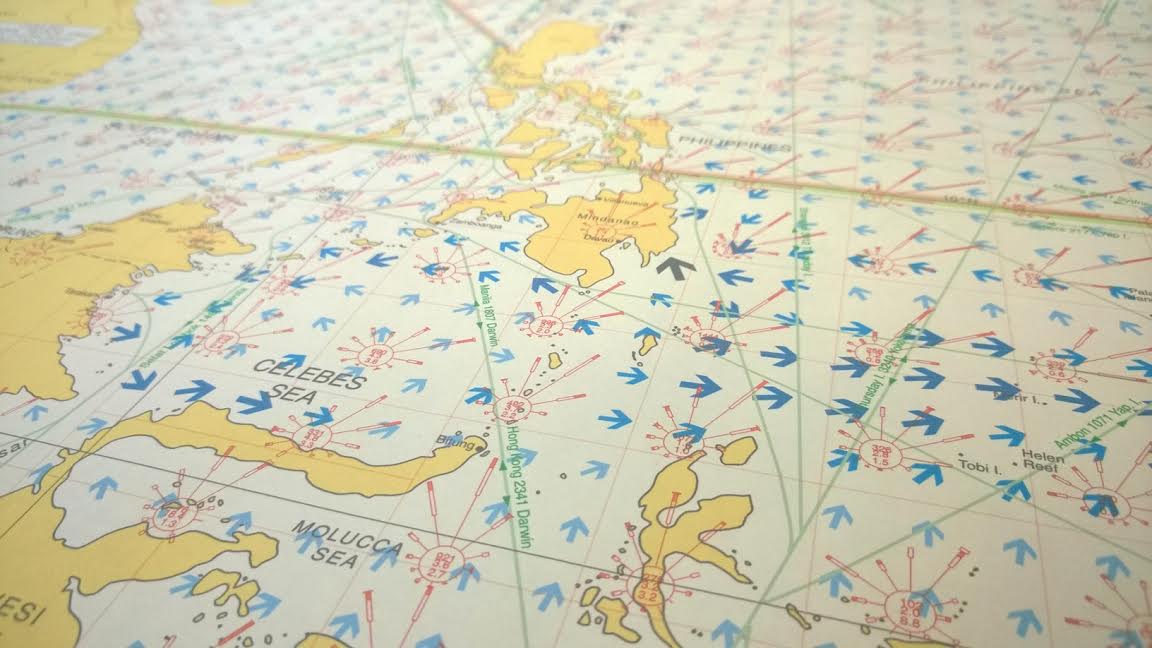
The United Kingdom Hydrographic Office is launching a new large-scale routeing chart covering the busy shipping waters of Vietnam, Indonesia and the Malacca Strait. Routeing Chart 5141 is the latest addition to the UKHO’s routeing chart series and will be published on 27 February 2014.
As well as covering a very busy shipping area, Routeing Chart 5141 has been compiled in a larger scale than the UKHO’s existing routeing charts and features more detailed and up-to-date meteorological and currents information. This includes a new method for displaying currents information, which has been designed by the UKHO to allow at-a-glance recognition alongside greater accuracy and resolution.
Routeing Chart 5141 includes a number of features to support safe and efficient voyage planning:
· Larger Scale – 1:10, 000, 000 scale to provide greater resolution and detail than smaller-scale routeing charts.
· High Density Currents arrows and wind roses are shown with an increased density over smaller-scale routeing charts, providing a higher-resolution representation of the data.
· Up-to-Date Data – New currents information is derived from forecasts and readings taken between 2000 and 2010, and with meteorological information newly sourced from the Met Office.
· Currents Grid – Currents data is displayed on a grid to provide a more accurate and consistent geographic representation of the data.
Nick Dekkers, Product Manager at the UKHO commented:
“The UKHO’s routeing chart series has proven to be very popular as a voyage planning tool, so it made sense to develop a new chart that covered the busy shipping waters of Vietnam and Indonesia, including the Malacca Strait. Routeing Chart 5141 will support safer shipping operations by delivering greater accuracy, detail and more up-to-date information, which will give vessels a better overview of the likely navigational conditions. When used in conjunction with ADMIRALTY Standard Navigational Charts, this new high-detail routeing chart will allow vessels to operate at the highest standards of safety.
“What’s more, by providing shipping companies with more detail and greater accuracy of data, they have the tools to make better use of sea conditions to plan fuel and time-efficient passages, which will help them to achieve cost savings.”
The publication of Routeing Chart 5141 is part of a major enhancement of the UKHO’s chart coverage of Vietnam and its suite of navigational charts and publications for Vietnamese waters. This includes new Electronic Navigational Chart (ENC) coverage for Vietnam available now in the ADMIRALTY Vector Chart Service; new and updated paper charts covering Vietnamese waters and updated publications covering tidal data, radio signals and sailing directions.
For further details on availability of Routeing Chart 5141 and other ADMIRALTY charts and publications, please contact an ADMIRALTY Chart Agent: http://www.admiralty.co.uk/SitePages/Distributors.aspx
About the United Kingdom Hydrographic Office
1. UKHO, an Executive Agency of the Ministry of Defence, has been charting the world’s oceans for more than 200 years with the primary aim of providing navigational products and services for the Royal Navy and merchant mariners to save and protect lives at sea. In addition it serves small craft and leisure mariners and provides a range of consultancy services.
2. UKHO also plays a central role, in support of the Maritime and Coastguard Agency, in discharging the navigation element of the UK’s Safety of Life at Sea Treaty obligations for waters of UK national responsibility.
3. UKHO produces a worldwide series of some 3, 500 paper nautical charts, 200 publications under the ADMIRALTY brand and Electronic Navigational Charts (ENCs). The ADMIRALTY portfolio is sold globally and used by nearly 70% of international shipping.
“Jo”